Protecting farmland bird nests with drones and AI

A new study from the University of Helsinki shows that nests of farmland birds can be located using a drone in combination with artificial intelligence.
The University of Helsinki recently published a study that shows drones and artificial intelligence show promise for conservation of farmland bird nests.
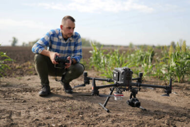
Drone with a thermal camera
Researchers flew a drone carrying a thermal camera over agricultural fields to record images. These were then fed to an artificial intelligence algorithm capable of accurately identifying nests, a first step to aid their protection. Researchers tested the system in Southern Finland near University of Helsinki’s Lammi Biological Station, using wild nests with eggs of the Lapwing Vanellus vanellus.
Text continues underneath image

“We have been involved in conservation of ground-nesting farmland birds for years, and realized how difficult it is to locate nests on the ground. At least at high latitudes, the temperature of these nests is typically higher than that of the surrounding environment. Hence, we thought that thermal cameras could assist”, says Andrea Santangeli, an Academy of Finland fellow at the Finnish Museum of Natural History Luomus, University of Helsinki.
Farmland bird species are declining over most of Europe. Birds breeding on the ground are particularly vulnerable because they are exposed to mechanical operations, like ploughing and sowing, which take place in spring and often accidentally destroy nests.
Thermal vision hampered by vegetation
According to Santangeli, a small pilot study indicated that thermal vision is hampered by vegetation and objects on the ground. “Therefore, to make this an efficient system, we thought that the camera could be flown using a drone, and artificial intelligence could help to analyse the resulting thermal images. We show that this works. However, the system performed best under cloudy and cold conditions, and on even grounds.”
Text continues underneath images
-
Schematic representation of the integration of a system for nest location within the practice of precision agriculture. Thermal images are processed by artificial intelligence (AI) specifically trained to automatically locate nests from thermal images. The geo-location of identified nests will then be transferred to the tractor that can be automatically programmed to avoid the nest through field operations, e.g. by changing direction or lifting the sower/harvester. – Figure: Nature
-
Schematic representation of the key steps of this study, from extensive nest search at selected fields (A), to flying the drone carrying the thermal sensor along a pre-programmed route over the field (B), preparing the thermal images by extracting the coordinates of the box drawn around the nest (C), and finally applying a neural network deep learning algorithm to classify images as having or not having a nest (D). – Figure: Nature
 specifically trained to automatically locate nests from thermal images. The geo-location of identified nests will then be transferred to the tractor that can be automatically programmed to avoid the nest through field operations, e.g. by changing direction or lifting the sower/harvester. - Figure: Nature")
, to flying the drone carrying the thermal sensor along a pre-programmed route over the field (B), preparing the thermal images by extracting the coordinates of the box drawn around the nest (C), and finally applying a neural network deep learning algorithm to classify images as having or not having a nest (D). - Figure: Nature")
Integrate bird nest detection in precision agriculture
The researchers say studies like this one can help pave the way to integrate bird nest detection within the drone borne sensors used in precision agriculture, and automate a system for saving those nests.
“A next and most challenging step will be to test our system in different environments and with different species. Our auspice is that this system will be, one day, fully integrated into agricultural practices, so that detecting and saving nests from mechanical destruction will become a fully automated part of food production,” says Santangeli.
Original article:
Andrea Santangeli, Yuxuan Chen, Edward Kluen, Raviteja Chirumamilla, Juha Tiainen, John Loehr. Integrating drone-borne thermal imaging with artificial intelligence to locate bird nests on agricultural land.
Join 17,000+ subscribers
Subscribe to our newsletter to stay updated about all the need-to-know content in the agricultural sector, two times a week.