Compact navigation systems for unmanned drones of the future

When Unmanned Aerial Vehicles (UAVs) or drones are used to survey industrial buildings, map terrain, or transport cargo for the logistics sector, they need to be as lightweight as possible, but carry the greatest possible payload. German institute Fraunhofer IZM has developed a compact and lightweight navigation unit (IMU) for such drones, which enables centimeter-perfect accuracy that was previously unattainable for civilian applications.
The aim of the IMUcompact research project was to develop a unit that can track the position of autonomous drone systems with pinpoint accuracy. The inertial measurement unit (or IMU for short) at the heart of the system essentially uses three gyroscope axes and three acceleration sensors to establish a position in navigation uses or map terrain with centimeter-level precision, even without a GPS signal.
Compact, low-resolution gyroscopes are now found in most smartphones and smartwatches, for example to determine the orientation of the screen or camera. Although these so-called MEMS gyroscopes are also small and lightweight, they are easily affected by environmental forces like changes in the temperature, humidity, or electromagnetic fields. This made them less suitable for use on drones, but IMU systems with higher resolutions used to be no feasible option for industry or commercial use due to their size and cost.
Optic miniature gyroscope
The interferometric fiber optic miniature gyroscope (IFOG) developed at Fraunhofer Institute for Reliability and Microintegration IZM enables a higher level of detail and can be fitted to a wide variety of carrier drones due to its compactness and low weight. As IFOGs contain no moving parts and are electromagnetically insensitive, they are far better suited for use in UAVs than conventional MEMS alternatives.
A novel assembly method was developed to make sure that the electronic and optical components of the IMU can be arranged in such a way that a high degree of miniaturization is achieved without compromising on accuracy. Conventional IMUs only have a resolution in the range of 25 to 30cm. By comparison, the gyroscope developed at Fraunhofer IZM now offers an absolute accuracy of less than 10cm.
The special arrangement of the measuring components on a 3D-printed optical bench also gives it great mechanical strength for industrial applications, all while keeping the weight very low. In addition, the researchers developed an application-specific circuit board, with a robust and compact design.
Photogrammetric measurements from the air
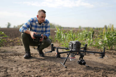
One of the first practical applications of the new IMU is photogrammetry with UAVs. Photogrammetry is the technology for measuring and identifying physical objects using a combination of 2D images and 3D measurement methods such as LIDAR. In this case, the weight of the IMU must not exceed 5 kg. Possible applications for drone-based photogrammetry include the automated surveying of factory buildings, the technical monitoring of offshore wind turbines, or automated stocktaking in agriculture and livestock farming. Drone-based photogrammetry can also make an important contribution for damage assessments in disaster areas, especially when large areas are affected by unexpected environmental events. Providers of online mapping services also use photogrammetric methods to create digital 3D maps, although this often required the cost-intensive use of aircraft or gyrocopters with the necessary measurement technology on board.
Join 17,000+ subscribers
Subscribe to our newsletter to stay updated about all the need-to-know content in the agricultural sector, two times a week.